The best hiking trails in North Carolina span a rich tapestry of landscapes, from the misty Blue Ridge Mountains to cascading waterfalls, peaceful river walks, and sweeping scenic overlooks.
You know what makes these trails truly special? They cater to everyone: beginners taking their first steps into the woods and seasoned hikers seeking challenging climbs or panoramic views.
North Carolina’s hiking experiences aren’t just about exercise; they’re about immersing yourself in nature. Picture wandering past mossy streams, hearing distant waterfalls, or spotting wildlife along the trail.
This guide walks you through the state’s most memorable hikes, detailing difficulty, distance, duration, and insider tips.
Whether you’re curious about short scenic loops or the best long hikes in North Carolina, we cover it all. We’ll help you plan your adventure smartly, know what to expect, and make the most of every step.
This guide is based on firsthand trail experience, local insights, and repeated hikes across western North Carolina.
20 Best Hikes in North Carolina Mountains
North Carolina doesn’t just offer a few pretty paths through the woods. It delivers ridgeline sunrises, roaring waterfalls, quiet river walks, bald summits, and serious backcountry routes that test your grit.
So what makes the best hiking trails in North Carolina truly stand out? Variety. You can start the morning chasing waterfalls in Pisgah, catch sunset on a Blue Ridge summit, and still make it back for dinner in town.
Whether you’re searching for hiking trails in NC with waterfalls, gentle greenways, or the best long hikes in North Carolina, this list balances scenic beauty with practical details.
Let’s get into the trails that locals recommend, weekend hikers repeat, and seasoned backpackers respect.
1. The Cascades Trail (Hiking Trails In NC With Waterfalls)
Tucked off the Blue Ridge Parkway at Milepost 271, The Cascades Trail is one of the most rewarding hiking trails in NC with waterfalls. It feels quiet, almost hidden. And then you hear it. The steady rush of water pulls you forward.
Before we get into the feel of the trail, here’s the quick snapshot hikers usually want first.
Trail Distance, Difficulty, and Elevation
| Detail | Information |
| Trail Name | The Cascades Trail |
| Location | Blue Ridge Parkway Milepost 272.5, Purlear, NC 28665, United States |
| Distance | 3.4 miles round trip |
| Difficulty | Moderate |
| Elevation Change | Approx. 750 feet descent and climb back |
| Duration | 1.5 to 2.5 hours |
| Starting Point | Cascades Parking Area, MP 271 |
| Ending Point | 60 foot Cascades Waterfall |
| Trail Type | Out and back |
| Best Season | Spring through Fall |
| Dog Friendly | Yes, on leash |
What Makes Cascades Trail Special
- Seasonal changes create a different experience each visit
- Continuous views of waterfalls rather than a single main fall
- Peaceful forest setting with shaded sections
- Cooling mist and lower temperatures near the water
- Excellent opportunities for photography and nature observation
Best Time to Visit the Cascades Trail
- Best season: Spring to early summer
- Strongest waterfall flow after rainfall or snowmelt
- Early morning hikes offer fewer crowds
- Fall provides scenic foliage, but reduced water flow
- Avoid or use caution after heavy rain due to slippery trails
Trail Note: We recommend hiking this trail in the spring after rainfall when the waterfall flow is strongest.
2. Max Patch (Best Hikes In North Carolina Mountains)
Max Patch is one of the most photographed Best Hiking Trails in North Carolina for a reason. It is simple, open, and wildly scenic. No dense forest walls. No technical scrambling.
Just a grassy bald sitting at 4,629 feet with uninterrupted 360-degree Appalachian views. You step out of your car and the horizon already feels close.
Let us explain why this small loop keeps landing on every serious list of best hikes in the North Carolina mountains.
A Quick Snapshot Before You Lace Up
Here is the technical breakdown hikers usually want first.
| Detail | Information |
| Location | Q2WV+R7 Joe, North Carolina, USA |
| Elevation | 4,629 feet |
| Distance | 1.5 miles loop |
| Trail Type | Loop with Appalachian Trail connector |
| Difficulty | Easy |
| Duration | 45 minutes to 1 hour |
| Elevation Gain | Approx. 300 feet |
| Starting Point | Max Patch Parking Area on Max Patch Road |
| Ending Point | Returns to same parking lot |
| Dog Friendly | Yes, leashed |
| Best Season | Spring through Fall |
It is short. Yes. But short does not mean small in impact.
Packing stress-free for your Smoky Mountains trip? Don’t miss the Ultimate Smoky Mountains Packing List 2026: Stress-Free 101 Guide, your go-to for hiking essentials and more.
Why Max Patch Is One of the Most Photographed NC Hikes
- Sweeping views of the Blue Ridge and Smoky Mountains
- Rolling green summit that looks dramatic in all seasons
- Popular for sunrise, sunset, and stargazing photography
- Wildflowers in late spring and golden grasses in fall
- Iconic Appalachian Trail scenery with wide-open skies
Max Patch Loop vs Appalachian Trail Connector
- Max Patch Loop Trail
- Short and easy (about 1.4 miles)
- Ideal for casual hikers and families
- Direct access to the summit
- Appalachian Trail Connector
- Longer approach with more elevation change
- Better for hikers seeking a quieter, more immersive experience
- Connects Max Patch to a legendary long-distance trail
Sunrise and Sunset Hiking Tips
- Arrive early for sunrise—parking fills up fast, especially on weekends
- Expect strong winds and cooler temperatures, even in summer
- Bring layers; the summit is fully exposed to the weather
- Use a headlamp for low-light hiking
- Stay well after sunset only if prepared for sudden fog and wind shifts
Max Patch Tip: Based on firsthand hikes, Max Patch is windy year-round, busiest at summer sunsets, quieter at sunrise, and prone to sudden weather changes.
Max Patch is one of the best hiking trails in North Carolina, offering iconic bald summit views and unforgettable panoramic scenery.
3. Bass Lake – Easy Hiking Trail in Blowing Rock, NC
If you are looking for one of the easiest and most relaxing North Carolina hiking trails, Bass Lake in Blowing Rock feels almost tailor-made.
It is calm. It is scenic. And honestly, it is the kind of trail where you can talk without losing your breath.
Located just off Bass Lake Drive near the Moses H. Cone Memorial Park access area in Blowing Rock, this 1-mile loop circles a peaceful mountain lake at about 3,400 feet elevation.
The trail both starts and ends at the Bass Lake parking area on Bass Lake Drive, making navigation simple even for first-time visitors.
Quick Trail Facts At A Glance
| Feature | Details |
| Distance | 1 mile loop |
| Difficulty | Easy |
| Trail Type | Loop |
| Duration | 20 to 40 minutes |
| Elevation Gain | Minimal, mostly flat |
| Surface | Packed gravel and paved sections |
| Dog Friendly | Yes, on leash |
| Kid Friendly | Yes |
| Location | 1 Bass Lake Dr, Blowing Rock, NC 28605, United States |
Why Bass Lake Is Ideal for Beginners and Families
- Short, easy loop with minimal elevation change
- Well-maintained trail suitable for all ages
- Calm, scenic environment ideal for first-time hikers
- Benches and picnic spots along the route
- Safe and relaxed hiking experience for families
Wildlife and Scenic Highlights Around Bass Lake
- Peaceful lake views with forest reflections
- Frequent sightings of ducks, geese, and songbirds
- Occasional turtles and deer near the shoreline
- Seasonal wildflowers and changing foliage
- Scenic mountain backdrop for photography
Managed by Moses H. Cone Memorial Park, ensuring well-maintained, safe, and protected trails
Bass Lake is one of the best hiking trails in North Carolina for beginners and families
4. Fontana Dam And Visitor Center
Tucked along the edge of the Great Smoky Mountains, Fontana Dam is not your typical forest trailhead. It is concrete, colossal, and surprisingly beautiful.
Part engineering marvel, part mountain overlook, this stop blends history with high-elevation views. If you enjoy North Carolina hiking trails that feel different from woodland paths, this one stands out.
Before we get into the numbers, here is the quick snapshot.
Fontana Dam Trail Overview
| Feature | Details |
| Location | 1001 Fontana Dam Rd, Fontana Dam, NC 28733, United States |
| Trail Type | Out and back with connecting paths |
| Distance | Minimal on the dam, moderate on AT section |
| Difficulty | Easy to moderate |
| Duration | 1 to 2 hours |
| Elevation Gain | Appalachian Trail overlook or return to the visitor center |
| Starting Point | Fontana Dam Visitor Center parking lot |
| Ending Point | Appalachian Trail overlook or return to visitor center |
| Best Season | Spring through Fall |
Combining History and Hiking in the Smoky Mountains
- Educational exhibits explaining the dam’s construction and impact
- Historical significance tied to World War II-era development
- Informational signs along the walk enhance learning
- Great mix of light hiking and cultural exploration
- Ideal stop for families and road-trip travelers
Appalachian Trail Access at Fontana Dam
- One of the most well-known access points to the Appalachian Trail
- Popular rest and resupply stop for thru-hikers
- Gateway to longer hikes into the Smoky Mountains
- Clearly marked trail connections near the dam
- Opportunities to see long-distance hikers in season
Best Scenic Overlooks Near the Dam
- Overlooks with sweeping views of Fontana Lake
- Excellent photo spots, especially on clear days
- Sunrise and sunset lighting add dramatic scenery
- Benches are available for resting and enjoying the views
- Safe, designated viewing areas with railings
Located near the Great Smoky Mountains National Park, with clear safety signage, railings, and maintained walkways
Posted warnings and marked paths help ensure a safe visitor experience
Fontana Dam Trail is one of the best hiking trails in North Carolina, offering an easy, scenic walk that blends history, views, and access to iconic mountain trails
Discover Great Smoky Mountains National Park Places to Stay in 2026
5. Murphy River Walk – Easy River Walk in Western NC
If you want one of the most relaxing North Carolina hiking trails, the Murphy River Walk in Murphy, NC, is hard to beat. It is not dramatic. It is not steep. And that is exactly the point.
Located in downtown Murphy in Cherokee County, this paved greenway stretches along the Valley River and feels more like a peaceful community path than a rugged backcountry trek.
Yet it still earns its place among the best hiking trails in North Carolina for easy days.
Murphy Trail Snapshot At A Glance
| Feature | Details |
| Location | River Walk, Murphy, NC 28906, United States |
| Trail Type | Out and back paved greenway |
| Distance | About 2 miles round trip |
| Elevation Gain | Minimal, under 50 feet |
| Difficulty | Easy |
| Average Duration | 45 minutes to 1 hour |
| Trail Surface | Fully paved |
| Dog Friendly | Yes, on leash |
| Parking | Konehete Park parking area |
Why This Is One of the Most Relaxing NC Walking Trails
- Gentle river sounds create a calm, peaceful atmosphere
- Shaded sections help keep the walk comfortable
- Scenic views of water, trees, and surrounding hills
- Low traffic and slower pace compared to mountain hikes
- Ideal for stress-free walks, families, and seniors
Best Seasons for a River Walk in Murphy
- Spring: Mild temperatures and blooming greenery
- Summer: Lush scenery with cooling river breezes
- Fall: Colorful foliage reflected on the water
- Winter: Quiet, peaceful walks with fewer visitors
- Best enjoyed in the morning or early evening year-round
Murphy River Walk is one of the best easy walking trails in North Carolina, offering a calm riverside experience in the heart of Western NC
6. Glen Burney Trail – Waterfalls Near Blowing Rock
If you’re searching for hiking trails in NC with waterfalls that feel wild yet accessible, Glen Burney Trail delivers.
Tucked just off downtown Blowing Rock, this 3-mile out-and-back trail drops you into a shaded gorge carved by New Year’s Creek. It’s beautiful. It’s steep. And yes, your calves will notice.
Before we get into the details, here’s a quick snapshot.
Glen Burney Trail Overview At A Glance
| Feature | Details |
| Location | 243 Laurel Ln, Blowing Rock, NC 28605, United States |
| Trail Type | Out and back |
| Distance | 3 miles round trip |
| Elevation Change | Approx. 800 feet descent and climb back |
| Difficulty | Moderate to strenuous |
| Duration | 2 to 3 hours |
| Starting Point | Glen Burney Trailhead on Laurel Lane |
| Ending Point | Glen Burney Falls |
| Waterfalls | Glen Marie Falls, Glen Burney Falls, Cascade Falls |
| Best Season | Spring through fall |
Three Waterfalls on One Steep NC Trail
- Glen Burney Falls: Largest and most impressive waterfall
- Glen Marie Falls: Tall, narrow cascade farther down the trail
- Upper Cascade: Smaller but scenic waterfall along the route
- Continuous water features make the descent visually rewarding
- One of the few trails in NC offering multiple waterfalls in a short distance
Elevation and Safety Considerations
- Steep downhill hike on the way in
- Strenuous uphill climb on the return
- Uneven terrain with roots, rocks, and steps
- Slippery sections near waterfalls and creek crossings
- Proper hiking shoes and pacing are essential
When Glen Burney Falls Flows Best
- Best water flow in spring due to rain and snowmelt
- Strong flow after consistent rainfall
- Summer flow may reduce during dry periods
- Fall offers lighter flow but beautiful foliage
- Winter can bring icy conditions to shaded sections
Glen Burney Tip :
- The return climb is steep and physically demanding, especially for beginners
- After rain, the trail can become muddy and slippery, increasing fall risk
- Take breaks, use trekking poles if needed, and avoid hiking during or immediately after heavy rain
Glen Burney Trail is one of the best hiking trails in North Carolina, combining challenging terrain with rewarding waterfall views near Blowing Rock
7. The Greenway Trail (North Carolina Hiking Trails For Beginners)
Looking for one of the most accessible North Carolina hiking trails that still feels refreshing? The Greenway Trail in Boone is exactly that.
It is simple, scenic, and surprisingly calming for an urban setting. Perfect for first timers.
The Greenway Trail Quick Facts At A Glance
Here is the snapshot hikers usually want before lacing up:
| Detail | Information |
| Location | North Carolina 28607, USA |
| Total Distance | 4 miles one way |
| Trail Type | Out and back with multiple connectors |
| Difficulty | Easy |
| Elevation Gain | Minimal, mostly flat |
| Duration | 1.5 to 2 hours round trip |
| Surface | Paved asphalt and concrete |
| Dog Friendly | Yes, on leash |
| Best Season | Spring through Fall |
It is one of the most beginner friendly nc hiking trails you will find in the High Country.
Best Urban Hiking Trail in the High Country
- Combines nature with town accessibility
- Peaceful river and forest scenery within city limits
- Popular with locals for daily exercise
- Minimal elevation change compared to mountain trails
- Great option for casual outdoor time without long drives
Connector Trails and Access Points
- Multiple trailheads throughout Boone
- Connects to local parks and neighborhoods
- Easy access from downtown Boone
- Parking is available at designated access points
- Allows short walks or longer out-and-back routes
Walking, Running, and Biking Rules
- Multi-use trail shared by pedestrians and cyclists
- Keep right and pass on the left
- Cyclists should yield to pedestrians
- Dogs allowed on leash
- Follow posted signs and speed guidelines for safety
Boone Greenway Trail is one of the best beginner-friendly hiking trails in North Carolina, offering a safe, scenic, and accessible outdoor experience in the High Country
8. Moore Cove Falls (Hiking Trails In NC With Waterfalls)
Tucked inside Pisgah National Forest, Moore Cove Falls is one of those North Carolina hiking trails that feels almost cinematic.
It is short, gentle, and leads to a 50-foot waterfall you can actually walk behind. Yes, behind it. And that little detail? It changes everything.
Quick Trail Facts At A Glance
| Detail | Information |
| Location | Pisgah National Forest near Brevard, NC |
| Trailhead | Moore Cove Falls Parking Area on US Highway 276 |
| Distance | 1.4 miles round trip |
| Difficulty | Easy |
| Elevation Gain | Approx. 120 feet |
| Duration | 30 to 45 minutes |
| Trail Type | Out and back |
| Waterfall Height | Approx. 50 feet |
| Dog Friendly | Yes, on leash |
Why Moore Cove Falls Is One of the Best Waterfall Hikes in NC
- Features a 50-foot cascading waterfall
- Unique path allows hikers to walk behind the falls
- Lush greenery and moss-covered rocks year-round
- Cool mist near the waterfall adds to the experience
- Excellent photography spot in all seasons
Trail Conditions and Accessibility
- Mostly dirt trail with some roots and rocks
- Gentle incline suitable for beginners
- Can become muddy after rainfall
- Not stroller- or wheelchair-accessible
- Proper footwear is recommended for wet conditions
Best Time to Visit Moore Cove Falls
- Spring: Strongest water flow after rain and snowmelt
- Summer: Cooler temperatures near the falls
- Fall: Colorful foliage with lighter water flow
- Winter: Ice formations are possible during cold spells
- Early mornings help avoid crowds
Moore Cove Falls Trail Tip:
- From firsthand visits, the trail is easy but can be slippery after rain, especially near the base of the waterfall
- Water flow is most impressive after recent rainfall, but expect more visitors on weekends
- Moore Cove Falls is located within Pisgah National Forest, where maintained trails and posted safety guidance help ensure a safe hiking experience
Moore Cove Falls is one of the best hiking trails in North Carolina, with waterfalls, offering an accessible, family-friendly hike with a rewarding scenic payoff.
9. Hickory Nut Falls Trail – Hiking Trails in NC With Waterfalls
Tucked inside Chimney Rock State Park, the Hickory Nut Falls Trail is one of the most iconic hiking trails in NC with waterfalls.
It leads you to a towering 404-foot cascade, often listed among the tallest waterfalls east of the Mississippi River. Short? Yes. Easy? Mostly. Memorable? Absolutely.
Trail Snapshot At A Glance
Here’s the quick breakdown before you lace up:
| Detail | Information |
| Trail Name | Hickory Nut Falls Trail |
| Location | Chimney Rock State Park, NC |
| Distance | 1.4 miles round trip |
| Elevation Gain | Approx. 300 feet |
| Difficulty | Easy to Moderate |
| Average Duration | 45 minutes to 1 hour |
| Trail Type | Out and back |
| Trail Surface | Gravel, packed dirt, some rocky sections |
| Starting Point | Chimney Rock parking area |
| Ending Point | Base of Hickory Nut Falls |
Why Hickory Nut Falls Is One of the Most Impressive NC Waterfalls
- One of the tallest waterfalls in North Carolina at nearly 400 feet
- Dramatic vertical drop visible from the base overlook
- Surrounded by towering cliffs and forest scenery
- Featured in films and photography for its scale
- Consistent water flow throughout much of the year
Trail Conditions and Accessibility
- Wide, paved trail with gradual elevation gain
- Benches are available along the route
- Not fully wheelchair-accessible due to the grade
- Safe viewing platform at the waterfall base
- Clear signage throughout the trail
Best Time to Visit Hickory Nut Falls
- Spring: Strong water flow after seasonal rains
- Summer: Cooler temperatures near the falls
- Fall: Stunning foliage paired with the waterfall
- Winter: Reduced flow but fewer crowds
- Early mornings offer quieter conditions
👉 Hickory Nut Falls Trail Tip :
- From real visits, the trail is easy but steadily uphill, making the return more noticeable for some hikers
- The paved surface can feel slick after rain, so wear shoes with good traction
- Managed by Chimney Rock State Park, the trail benefits from maintained paths, safety railings, and posted warnings
Hickory Nut Falls Trail is one of the best hiking trails in North Carolina with waterfalls, combining accessibility with one of the state’s most dramatic natural features
10. Rough Ridge Lookout – Iconic Blue Ridge Parkway Viewpoint
Rough Ridge Lookout is one of the most photographed North Carolina hiking trails on the Blue Ridge Parkway. It is short, yes. But don’t let the distance fool you. The views feel huge.
This trail sits at Milepost 302.8 on the Blue Ridge Parkway, near Grandfather Mountain. It’s popular for sunrise.
And honestly, once you see the first light spill across the Blue Ridge Mountains, you’ll understand why people wake up at 5 a.m. for it.
Rough Ridge Lookout Trail Snapshot At A Glance
| Detail | Information |
| Location | 3218 Blue Ridge Pkwy, Linville, NC 28646, United States |
| Region | Near Boone and Blowing Rock |
| Distance | 1.5 miles round trip |
| Trail Type | Out and back |
| Elevation Gain | Approx. 400 feet |
| Difficulty | Moderate |
| Duration | 45 minutes to 1.5 hours |
| Starting Point | Rough Ridge Parking Area |
| Ending Point | Rocky summit overlook |
| Dog Friendly | Yes, on leash |
Why Rough Ridge Is One of the Most Popular NC Lookouts
- Sweeping views of Grandfather Mountain and surrounding peaks
- Elevated boardwalks protect fragile alpine vegetation
- Dramatic rocky outcrops are perfect for photography
- Big views with minimal hiking distance
- One of the most accessible high-elevation overlooks in NC
Trail Conditions and Accessibility
- Mix of dirt trail, stone steps, and wooden boardwalks
- Narrow sections with drop-offs near viewpoints
- Not suitable for strollers or wheelchairs
- Handrails are present on most boardwalk sections
- Can be crowded due to roadside access
Best Time to Visit Rough Ridge Lookout
- Spring: Blooming rhododendrons and clear views
- Summer: Lush greenery with cooler mountain temperatures
- Fall: Peak foliage season with heavy crowds
- Winter: Snow and ice possible; trail may be unsafe
- Sunrise and weekday mornings are the least crowded
👉 Rough Ridge Lookout Tip:
- From firsthand visits, Rough Ridge is extremely busy during fall foliage and weekends, often with parking congestion
- The rocky and stair-heavy trail can be slippery after rain or frost, requiring caution
- Located along the Blue Ridge Parkway, the trail includes safety railings, boardwalks, and posted warnings to protect visitors and sensitive habitats
Rough Ridge Lookout is one of the best hiking trails in North Carolina, offering iconic Blue Ridge views with a short but memorable hike
11. Triple Falls Trail – One of the Best Waterfall Hikes in NC
If you’re searching for hiking trails in NC with waterfalls, this one usually tops the list. Located in DuPont State Recreational Forest near Brevard, the Triple Falls Trail is part of the Little River system and is widely considered one of the most photogenic North Carolina hiking trails.
Yes, it was featured in The Hunger Games, but honestly, the real-life drama of the falls steals the show.
Quick Trail Snapshot
| Detail | Information |
| Location | DuPont State Recreational Forest, near Brevard, NC |
| Trailhead | Hooker Falls Access Area parking lot |
| Distance | 2.2 miles round trip |
| Elevation Gain | Approx. 400 feet |
| Difficulty | Moderate |
| Duration | 1 to 1.5 hours |
| Trail Type | Out and back with stairs and rock steps |
| Dog Friendly | Yes, on leash |
Why Triple Falls Is One of the Most Iconic NC Waterfalls
- Features three dramatic cascading sections in one waterfall
- Powerful flow creates mist and thunderous sound
- Multiple viewpoints and overlooks along the trail
- Frequently used as a filming location for movies
- One of the most photographed waterfalls in North Carolina
Trail Conditions and Accessibility
- Mostly wide gravel paths with a gradual elevation change
- Short spur trails lead to overlooks and viewing platforms
- Some uneven footing near the falls
- Not stroller- or wheelchair-friendly near viewpoints
- Benches and open areas for resting and photos
Best Time to Visit Triple Falls
- Spring: Strongest and most impressive water flow
- Summer: Lush greenery and cooler forest shade
- Fall: Colorful foliage with slightly reduced flow
- Winter: Fewer crowds, but icy patches are possible
- Early mornings and weekdays are best for avoiding crowds
👉 Triple Falls Trail Tip:
- From real visits, Triple Falls is very busy on weekends, especially midday
- Viewing areas can be slick from mist, so wear shoes with good traction
- Located within DuPont State Recreational Forest, where maintained trails, viewing platforms, and posted safety signage help ensure a safe and enjoyable hike
Triple Falls Trail is one of the best hiking trails in North Carolina, offering an easy-to-moderate hike with one of the state’s most powerful and scenic waterfalls
12. Lovers Leap Loop Trail – Scenic Loop Hike in Western North Carolina
Tucked above the charming town of Hot Springs, the Lovers Leap Loop Trail is one of those classic North Carolina hiking trails that balances effort with reward.
It is short, scenic, and surprisingly satisfying.
Quick Lovers Leap Loop Trail Snapshot
Here is the essential data hikers usually ask for:
| Detail | Information |
| Location | 138 Silvermine Rd, Hot Springs, NC 28743, United States |
| Total Distance | 1.8 miles loop |
| Elevation Gain | Approx. 500 feet |
| Difficulty | Moderate |
| Average Duration | 1 to 1.5 hours |
| Trail Type | Loop |
| Trailhead | End of Bridge Street near Appalachian Trail crossing |
| Highest Point | Lovers Leap Overlook |
| Best Season | Spring and Fall |
Why Lovers Leap Is a Favorite Short Hike in NC
- Overlook provides panoramic views of Hot Springs and the French Broad River
- Unique connection to the Appalachian Trail
- Quick access from town with no long drive required
- Great reward-to-effort ratio
- Popular with both locals and AT thru-hikers
Trail Conditions and Accessibility
- Dirt trail with roots, rocks, and switchbacks
- Narrow sections near the overlook
- Not suitable for strollers or wheelchairs
- Can be slippery after rain
- Benches are located near the viewpoint
Best Time to Hike Lovers Leap Loop Trail
- Spring: Comfortable temperatures and fresh greenery
- Summer: Shaded forest helps with heat
- Fall: Excellent foliage views over town
- Winter: Quiet but icy conditions possible
- Early morning or late afternoon offers fewer crowds
👉 Lovers Leap Loop Trail Tip:
- From firsthand hikes, the climb is short but steep, especially on the AT section
- After rain, the trail can become muddy and slick, requiring careful footing
- As part of the Appalachian Trail network near town, the route is well-marked with signage and maintained for hiker safety
Lovers Leap Loop Trail is one of the best hiking trails in North Carolina, delivering stunning views and Appalachian Trail access in under two miles
13. Devil’s Courthouse – High-Elevation Viewpoint on the Blue Ridge Parkway
If you like your best hikes in the North Carolina mountains short, sharp, and dramatic, this one delivers.
It is not long. It is not gentle either. But what do you get at the top? Worth every step.
Devil’s Courthouse Quick Facts At A Glance
| Detail | Information |
| Location | North Carolina 28708, United States |
| Trail Type | Out and back |
| Distance | 1 mile round trip |
| Elevation Gain | About 260 feet |
| Summit Elevation | 5,720 feet |
| Difficulty | Moderate |
| Duration | 45 minutes to 1 hour |
| Starting Point | Devil’s Courthouse parking area off Blue Ridge Parkway |
| Ending Point | Summit overlook platform |
| Best Season | Late spring through fall |
Why Devil’s Courthouse Is One of the Best Scenic Overlooks in NC
- Elevation over 5,700 feet, offering sweeping long-range views
- Panoramic vistas of the Pisgah and Great Balsam Mountains
- Open, rocky summit ideal for photography
- One of the highest viewpoints accessible by a short hike
- Frequent clouds and mist create dramatic scenery
Trail Conditions and Accessibility
- Dirt and rock trail with exposed roots
- Steep final climb to the summit
- Not suitable for strollers or wheelchairs
- Limited space at the top—can feel crowded
- Extra caution is needed in wet or icy conditions
Best Time to Visit Devil’s Courthouse
- Summer: Cooler temperatures compared to lower elevations
- Fall: Exceptional foliage views, but very crowded
- Spring: Clearer skies with lingering cool air
- Winter: Snow and ice are common; the trail is often unsafe
- Early mornings offer fewer crowds and clearer views
👉 Devil’s Courthouse Tip :
- From real visits, the summit is often windy and significantly cooler than nearby areas
- Clouds and fog can roll in quickly, limiting visibility within minutes
- Located along the Blue Ridge Parkway, the trail includes posted warnings and maintained access, but hikers should still use caution near steep drop-offs.
Devil’s Courthouse is one of the best hiking trails in North Carolina, delivering dramatic high-elevation views with a short but challenging climb
14. Graveyard Fields – Hike and Waterfalls Along the Blue Ridge Parkway
Tucked along the Blue Ridge Parkway, this is one of the most loved North Carolina hiking trails for good reason.
You get waterfalls, mountain meadows, and blueberry patches all in one compact loop. It feels wild, but it is surprisingly accessible.
Quick Trail Facts At A Glance
| Detail | Information |
| Location | Graveyard Fields, Canton, NC 28716, United States |
| Total Distance | About 3.2 miles round trip |
| Elevation Gain | Approx. 340 feet |
| Difficulty | Moderate |
| Duration | 1.5 to 2.5 hours |
| Trail Type | Out and back with side trails |
| Best Season | Late summer for blueberries, fall for foliage |
| Dog Friendly | Yes, on leash |
Why Graveyard Fields Is One of the Best Waterfall Hikes in NC
- Features two major waterfalls: Upper Falls and Lower Falls
- Open valley landscape shaped by historic landslides
- Unique high-elevation meadows are uncommon in the region
- Great mix of waterfalls, mountain views, and open space
- One of the most diverse short hikes on the Parkway
Upper Falls vs Lower Falls
- Upper Falls:
- Shorter hike from the parking area
- Less steep and easier to reach
- Good option for families
- Lower Falls:
- Longer hike with stairs and elevation change
- Larger and more dramatic waterfall
- Requires more time and effort
Best Time to Visit Graveyard Fields
- Spring: Strong waterfall flow and blooming wildflowers
- Summer: Cooler temps at elevation, very popular
- Fall: Stunning foliage but extremely crowded
- Winter: Ice and snow possible; trail conditions can be hazardous
- Early mornings and weekdays are best for fewer crowds
👉 Graveyard Fields Tip:
- From real visits, trails can be very crowded, especially during summer and fall weekends
- Boardwalks, stairs, and rocks become slick after rain or frost, requiring careful footing
- Located along the Blue Ridge Parkway, Graveyard Fields has maintained paths, signage, and designated viewing areas, but visitors should stay on marked trails for safety
Graveyard Fields is one of the best hiking trails in North Carolina, offering waterfalls, open landscapes, and accessible adventure in one iconic stop
Need the perfect place to rest after a hike? Check out Cabin Rentals in NC: 7 Amazing Ultimate Picks (2026) for cozy mountain stays near the trails.
15. Oconaluftee River Trail – Easy Riverside Walk in the Smokies
Tucked inside the heart of the Great Smoky Mountains National Park, the Oconaluftee River Trail feels calm, almost meditative.
It is one of the few pet-friendly paths in the park and one of the most accessible North Carolina hiking trails for beginners.
Easy, scenic, and rich with wildlife, this trail proves that not every memorable walk needs steep switchbacks.
Oconaluftee River Trail Snapshot At A Glance
Here’s the quick breakdown hikers usually look for:
| Feature | Details |
| Distance | 3 miles round trip |
| Trail Type | Out and back |
| Difficulty | Easy |
| Elevation Gain | About 200 feet |
| Duration | 1 to 1.5 hours |
| Starting Point | Oconaluftee River Trail, Cherokee, NC 28719, United States |
| Ending Point | Cherokee town boundary at US 441 |
| Surface | Mostly gravel, relatively flat |
| Dogs Allowed | Yes, on leash |
Why Oconaluftee River Trail Is One of the Best Easy Hikes in NC
- Constant river views with peaceful water sounds
- Open meadows and forested sections along the route
- Frequent wildlife sightings, especially elk
- Minimal elevation gain makes it accessible to many hikers
- Great mix of nature and history near the Mountain Farm Museum
Trail Conditions and Accessibility
- Well-maintained dirt and gravel surface
- Mostly level terrain with gentle grades
- Stroller-friendly in many sections
- Benches and open areas for resting
- Can become muddy after heavy rain
Best Time to Hike Oconaluftee River Trail
- Spring: Wildflowers and a flowing river
- Summer: Shaded sections and cooler river air
- Fall: Peak elk activity and colorful foliage
- Winter: Quiet, scenic walks with fewer visitors
- Early mornings and evenings are best for wildlife viewing
👉 Oconaluftee River Trail Tip:
- From real visits, elk are commonly seen in the early morning and near dusk, especially in fall
- Wildlife can approach the trail—maintain a safe distance and follow posted rules
- Located within Great Smoky Mountains National Park, the trail is clearly marked with safety signage and maintained paths to ensure a safe hiking experience
Oconaluftee River Trail is one of the best hiking trails in North Carolina, offering an easy, scenic riverside walk with exceptional wildlife-viewing opportunities
16. Tsali Recreation Area – Scenic Trails Along Fontana Lake
Set along the southern shore of Fontana Lake inside Nantahala National Forest, Tsali Recreation Area is one of the most respected multi-use trail systems in western North Carolina.
Known for mountain biking in NC and scenic horseback riding trails, it offers four well-designed loops with steady climbs, flowing singletrack, and wide open lake views.
Trail Snapshot At A Glance
Here is the full breakdown of all four Tsali trails.
| Trail Name | Distance | Trail Type | Difficulty | Elevation Gain | Duration | Starting Point | Ending Point | Surface | Use Schedule |
| Right Loop | 13.9 miles | Loop | Moderate | Approx 1,500 feet | 3 to 5 hours biking | Tsali Trailhead, FR 1286 | Returns to trailhead | Narrow singletrack | Alternates bike and horse days |
| Left Loop | 11.9 miles | Loop | Moderate | Approx 1,200 feet | 2.5 to 4 hours | Tsali Trailhead | Returns to trailhead | Singletrack with creek crossings | Alternates use |
| Mouse Branch | 8.5 miles | Loop | Moderate | Approx 900 feet | 2 to 3 hours | Tsali Trailhead | Returns to trailhead | Singletrack and old road bed | Alternates use |
| Thompson Loop | 7.3 miles | Loop | Moderate | Approx 700 feet | 1.5 to 3 hours | Tsali Trailhead | Returns to trailhead | Narrow forest singletrack | Alternates use |
All trails begin at the main Tsali parking area at the end of Forest Road 1286 near Bryson City. Restrooms and a campground sit near the trailhead.
Why Tsali Is a Favorite Trail System in Western NC
- Scenic ridge sections overlooking Fontana Lake
- Quiet, less crowded atmosphere compared to nearby parks
- Smooth, flowing trails suitable for beginners and intermediates
- Balanced mix of shade and open views
- Ideal for long, steady hikes without steep climbs
Hiking and Biking Trail Options
- Multiple loop trails of varying distances
- Designated hiker-only and biker-only days
- Clearly posted schedules at trailheads
- Singletrack trails with gradual elevation changes
- Easy navigation with maps and signage
Best Time to Visit Tsali Recreation Area
- Spring: Mild temperatures and fresh greenery
- Summer: Shaded trails with cooling lake breezes
- Fall: Peak foliage and comfortable hiking weather
- Winter: Quiet conditions; occasional muddy sections
👉 Tsali Recreation Area Tip:
- From real visits, checking the daily trail-use schedule is essential before hiking
- Trails can become muddy after rainfall, affecting traction
- Managed by the Nantahala National Forest, Tsali features posted safety signage, maintained trails, and designated use days for visitor safety.
Tsali Recreation Area is one of the best hiking trails in North Carolina, offering scenic lake views, peaceful loops, and a well-managed multi-use trail system
17. Hawksbill Mountain Trail
Rising above the wild edges of Linville Gorge, Hawksbill Mountain Trail delivers one of the most dramatic summit views in North Carolina. Short, steep, and unforgettable, it leads to a rocky summit that overlooks the gorge and the layered peaks of the Blue Ridge.
If you are searching for iconic Linville Gorge hiking trails with maximum reward in minimal distance, this one earns its reputation.
Hawksbill Mountain Trail Snapshot At A Glance
Here is the full breakdown hikers usually want:
| Feature | Details |
| Distance | 1.5 miles round trip |
| Trail Type | Out and back |
| Difficulty | Moderate to strenuous |
| Elevation Gain | About 700 feet |
| Duration | 1 to 2 hours |
| Starting Point | Nebo, NC 28761, United States |
| Ending Point | Rocky summit overlook |
| Surface | Dirt trail with rock sections |
| Dogs Allowed | Yes, on leash |
The trailhead sits near Linville Gorge Wilderness, accessed via unpaved forest roads. High clearance vehicles help, especially after rain.
Why Hawksbill Mountain Offers Some of the Best Views in NC
- Elevation over 4,000 feet with sweeping gorge views
- Panoramic vistas of Table Rock and Linville Gorge
- Open rocky summit ideal for sunrise and sunset
- Wide viewing area with dramatic cliff edges
- Frequently ranked among the top NC viewpoints
Trail Conditions and Accessibility
- Dirt and rock trail with roots and uneven footing
- Steeper sections near the summit
- Not suitable for strollers or wheelchairs
- Limited shade near the top
- Use caution near cliff edges
Best Time to Hike Hawksbill Mountain Trail
- Spring: Clear views and comfortable temperatures
- Summer: Early morning or evening hikes recommended
- Fall: Exceptional foliage and heavy visitation
- Winter: Ice and wind are possible at the summit
👉 Hawksbill Mountain Tip:
- From firsthand hikes, the summit is often windy and cooler than the trailhead
- The exposed rock at the top can be slippery after rain or frost
- Located within the Linville Gorge Wilderness, where minimal development means hikers must rely on personal preparation and follow Leave No Trace principles
18. Catawba River Greenway
Stretching along the banks of the Catawba River in Morganton, the Catawba River Greenway is an easy riverside path built for relaxed miles.
It is flat, paved, and welcoming, which makes it one of the most accessible walking trails in North Carolina. If you want fresh air without a steep climb, this is your spot. And yes, it is dog-friendly.
Catawba River Greenway Trail Snapshot At A Glance
Here is the full breakdown walkers and cyclists look for:
| Feature | Details |
| Distance | 3.8 miles one way, about 7.6 miles round trip |
| Trail Type | Out and back with connector spurs |
| Difficulty | Easy |
| Elevation Gain | Minimal, mostly flat |
| Duration | 1 to 2 hours walking, under 1 hour biking one way |
| Starting Point | Freedom Park trailhead, 300 Collett Street |
| Ending Point | Catawba Meadows Park and River Village area |
| Surface | Paved asphalt greenway |
| Dogs Allowed | Yes, on leash |
Multiple access points allow shorter walks if you prefer.
Why Catawba River Greenway Is a Favorite Easy Trail in NC
- Peaceful riverside setting with shaded sections
- Multiple bridges and scenic river overlooks
- Accessible nature experience within city limits
- Well-maintained path with mile markers
- Ideal for casual exercise and relaxed walks
Trail Conditions and Accessibility
- Smooth, paved surface throughout
- Wheelchair- and stroller-friendly
- Gentle grades with no steep climbs
- Benches and rest areas along the route
- Clear signage and safety railings near bridges
Best Time to Visit the Catawba River Greenway
- Spring: Blooming trees and comfortable temperatures
- Summer: Shaded sections help with heat
- Fall: Colorful foliage along the river
- Winter: Quiet walks with fewer users
- Early mornings and weekdays are least crowded
19. Jackrabbit Hiking Trails
Set above the clear waters of Lake Chatuge near Hayesville, the Jackrabbit Hiking Trails combine mountain and lake views in a well-designed loop system.
Part of the Nantahala Ranger District in Nantahala National Forest, this network is known for smooth tread, steady climbs, and flexible route options.
It is popular with hikers and mountain bikers, but the layout keeps traffic flowing.
Trail Snapshot At A Glance
Here is the full breakdown of the Jackrabbit loop system:
| Feature | Details |
| Total Trail System | About 15 miles of connected loops |
| Main Loop Distance | Returns to the main trailhead |
| Extended Outer Loops | Up to 8 to 10 miles combined |
| Trail Type | Interconnected loops |
| Difficulty | Easy to Moderate |
| Elevation Gain | 1 to 4 hours, depending on mileage |
| Duration | 3.7-mile core loop |
| Starting Point | Jackrabbit Mountain Recreation Area trailhead off Jackrabbit Road |
| Ending Point | Returns to main trailhead |
| Surface | Packed dirt singletrack |
| Dogs Allowed | Yes, on leash |
Parking, restrooms, picnic tables, and lake access are available at the recreation area.
Why Jackrabbit Is a Great Trail System in Western NC
- Scenic overlooks of Lake Chatuge and the surrounding mountains
- Less crowded than the major national park trails
- Smooth, flowy paths are ideal for steady hiking
- Mix of shaded forest and open viewpoints
- Suitable for beginners and intermediate hikers
Trail Conditions and Accessibility
- Natural dirt and packed-earth surfaces
- Gradual elevation changes with a few moderate climbs
- Not stroller- or wheelchair-accessible
- Shared-use trails—hikers should stay alert for bikes
- Benches and rest areas at select viewpoints
Best Time to Visit Jackrabbit Hiking Trails
- Spring: Mild weather and fresh greenery
- Summer: Shaded trails with lake breezes
- Fall: Colorful foliage and clear views
- Winter: Quiet conditions; occasional muddy sections
From real visits, checking trail-use signage is important due to shared hiking and biking routes
After rain, some sections can become slick or muddy, especially on shaded slopes
Managed by the U.S. Forest Service, ensuring maintained trails, posted rules, and responsible recreation practices
20. Art Loeb Trail (Best Long Hikes In North Carolina)
The Art Loeb Trail is one of the most demanding and scenic long-distance hiking trails in North Carolina.
Stretching 30 miles across the spine of Pisgah National Forest, it connects hardwood forest, high balds, and exposed ridgelines.
This is true multi-day backpacking territory. Rugged. Remote. Unforgiving in spots. And unforgettable.
Trail Snapshot At A Glance
Here is the complete breakdown backpackers need:
| Feature | Details |
| Distance | 30 miles point to point |
| Trail Type | Point to point |
| Difficulty | Strenuous |
| Elevation Gain | About 8,000 feet cumulative |
| Duration | 2 to 4 days backpacking |
| Northern Starting Point | Daniel Boone Scout Trail near Camp Daniel Boone |
| Southern Starting Point | Davidson River Campground near Brevard |
| Highest Point | Near Black Balsam Knob at 6,214 feet |
| Surface | Dirt trail, roots, rock, exposed balds |
| Dogs Allowed | Yes, under control |
Most hikers travel south to north, finishing on the dramatic balds.
Why the Art Loeb Trail Is Legendary in NC
- Continuous high-elevation hiking with panoramic views
- Passes iconic areas like Black Balsam Knob and Cold Mountain
- Open balds, alpine meadows, and rugged wilderness terrain
- One of the toughest but most rewarding trails in the Southeast
- A bucket-list hike for experienced backpackers
Trail Difficulty and Elevation
- Strenuous: over 7,000 feet of total elevation gain
- Steep ascents and descents throughout
- Limited water sources on ridge sections
- Fully exposed areas with no shelter from the weather
- Requires strong navigation and endurance skills
Best Time to Hike the Art Loeb Trail
- Late spring to early fall is ideal
- Summer brings afternoon storms at high elevations
- Fall offers incredible views but colder nights
- Winter hiking is dangerous due to ice, wind, and exposure
- Weather conditions can change rapidly
👉 Art Loeb Trail Tip:
- From real thru-hikes, the Art Loeb Trail is physically demanding with little margin for error, especially in bad weather
- Long exposed stretches mean hikers must carry ample water, layers, and navigation tools
- Maintained by the Pisgah National Forest, but sections in designated wilderness receive minimal trail work, requiring advanced preparation.
The Art Loeb Trail is one of the best long hikes in North Carolina, offering unmatched views, rugged terrain, and a true backcountry challenge for experienced hikers.
Where To Stay Near The Best Hiking Trails In North Carolina
 1")
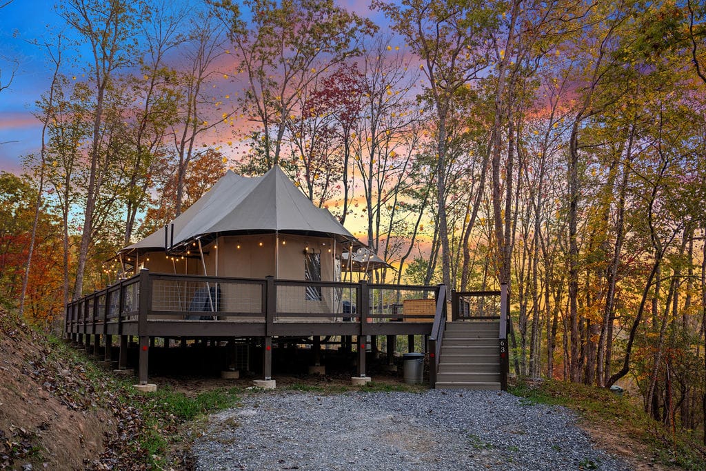
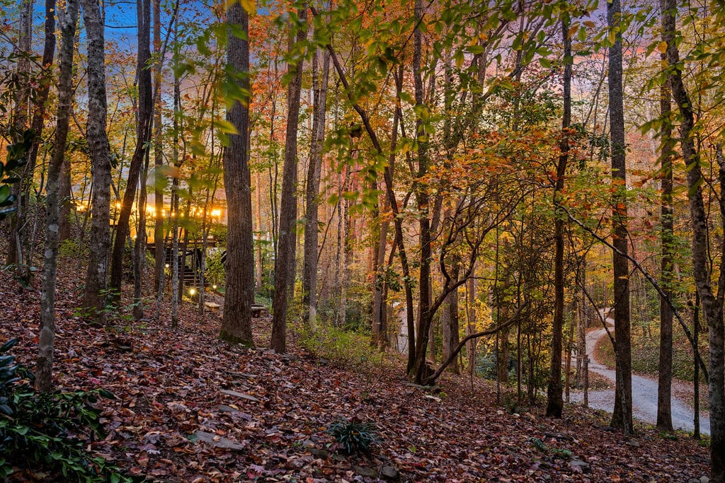
If you’re planning to explore the best hiking trails in North Carolina, having a comfortable and convenient base makes all the difference.
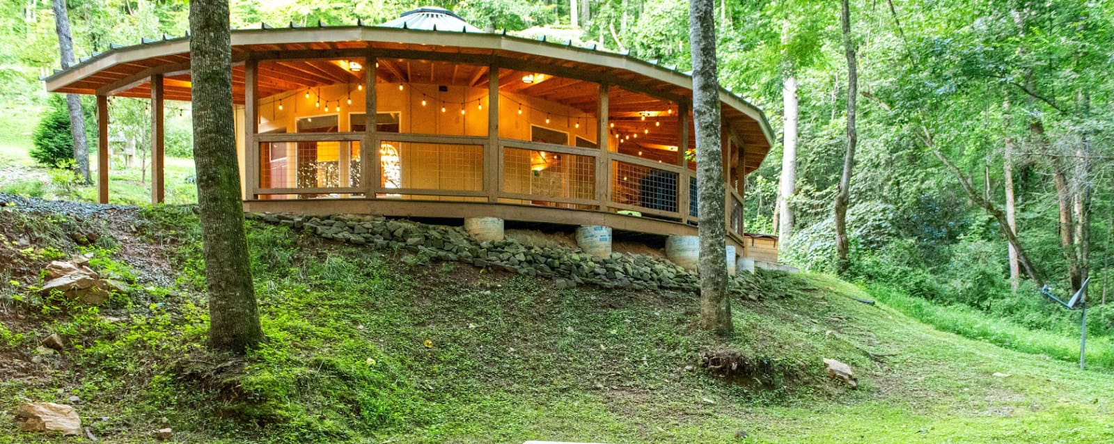
Elk Hollow Resort in Bryson City offers the perfect mix of adventure, luxury, and relaxation, making it an ideal spot for hikers, families, and couples alike.
Nestled in the Great Smoky Mountains, it’s just a short drive from top trails like the Oconaluftee River Trail and Art Loeb Trail.
Accommodation Options
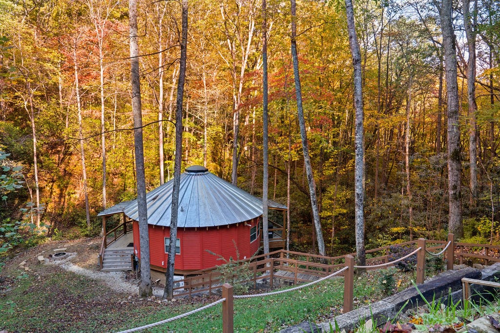
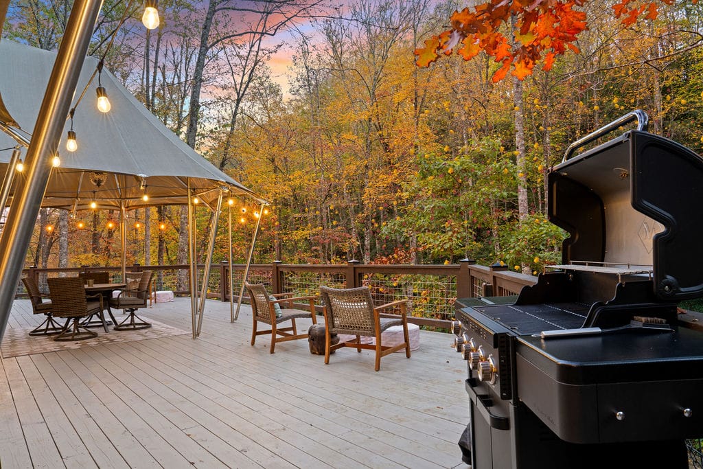
Elk Hollow Resort provides a range of unique stays, blending rustic charm with modern amenities:
| Accommodation Type | Features | Highlights |
| Safari Tents | Climate-controlled, king-size bed, private bathroom, full kitchen, spacious deck | Private hot tub, firepit, romantic string lights |
| Hard-Wall Yurts | Climate-controlled, king-size bed, full kitchen, private bathroom | Elevated deck, hot tub, mountain views |
| Cabin Lodges | 4 bedrooms, 4 bathrooms, full kitchen, large dining area, patio | Ideal for groups, sunset views, private hot tub & firepit |
You can choose based on your travel style—whether it’s glamping under the stars or a cozy cabin for a family getaway.
Amenities For Hikers
Elk Hollow Resort is designed with hikers in mind:
- Short drive access to many North Carolina hiking trails
- Fully stocked kitchens for cooking meals after a long day
- Private decks and firepits for evening relaxation
- Hot tubs for soothing tired muscles
- Peaceful, secluded surroundings for stargazing and wildlife spotting
Hiking Tips for Exploring North Carolina Hiking Trails
Exploring the North Carolina hiking trails can be magical, but it helps to be prepared. From misty waterfalls to mountaintop views, the trails offer beauty and a few surprises.
You know what? Being ready makes the adventure effortless and way more enjoyable. Here are some practical tips for your next hike.
What To Pack For NC Hiking Trails
 2")
Bonus tip: a lightweight rain jacket and a small first-aid kit never hurt. You’ll thank yourself if a sudden shower rolls in.
Safety Tips
Safety is non-negotiable. Before heading out:
- Check Weather: North Carolina trails can be slippery after rain or icy in winter.
- Wildlife Awareness: From elk in the Oconaluftee River Trail to black bears in the Smokies, know what might cross your path.
- Trail Maps: Don’t rely solely on your phone; cell coverage is spotty on many NC hiking trails.
Even familiar paths deserve a quick safety check; it’s better to be over-prepared than sorry.
Are Dogs Allowed on North Carolina Hiking Trails?
Many trails welcome dogs on leash, including the Oconaluftee River Trail and Catawba River Greenway.
- Keep pets leashed and hydrated
- Watch for wildlife
- Clean up after them
Honestly, a dog can make a hike even more fun, but responsibility is key. After all, the mountains are for everyone to enjoy safely.
Looking for more family fun? Discover Family Activities in North Carolina: 10 Epic Adventures (2026) and plan an unforgettable outing everyone will love.
Planning Your Adventure On The Best Hiking Trails In North Carolina
From easy riverside greenways to rugged climbs along Linville Gorge and sweeping balds in Pisgah National Forest, North Carolina hiking trails offer real variety.
You can choose short scenic loops, family friendly paths, or commit to multi day backpacking routes like the Art Loeb Trail.
Start with a trail that matches your current fitness level. Then push a little farther next time.
The mountains reward curiosity. Plan your hiking getaway, pack smart, and let the Blue Ridge do the rest.
FAQs | Best Hiking Trails in North Carolina
1. What Is The Most Famous Mountain In North Carolina?
Mount Mitchell is the highest peak east of the Mississippi River and one of North Carolina’s most iconic mountains.
2. What Is The Prettiest Place In North Carolina?
The Blue Ridge Parkway is widely considered the most scenic, offering waterfalls, overlooks, and lush mountain landscapes.
3. What Is The Most Beautiful Mountain Town In NC?
Blowing Rock is a charming town known for its scenic views, quaint streets, and proximity to top hiking trails.
4. What Is The Most Famous Hiking Trail In The US?
The Appalachian Trail is the most renowned long-distance trail, stretching over 2,190 miles from Georgia to Maine.
5. What Are The Big 3 Trails In The USA?
The Appalachian Trail, Pacific Crest Trail, and Continental Divide Trail are the “big three” long-distance hiking routes in the US.
6. Can You Lose Belly Fat By Hiking?
Yes, hiking is an effective full-body workout that burns calories and helps reduce belly fat when combined with a balanced diet.
7. Which State Has The Most Beautiful Hiking Trails?
North Carolina, Colorado, and California are often ranked among the top for diverse and scenic hiking trails.
8. What Are The Biggest Risks Of Living In North Carolina?
Flooding, hurricanes, and occasional wildlife encounters are notable risks, though most areas remain safe for residents and hikers.
9. How Far Is Asheville From The Mountains?
Asheville sits in the Blue Ridge Mountains, so most major trails and overlooks are within a 30–60 minute drive.
10. Is Hiking Better Than Walking?
Hiking is more intense than walking, offering greater calorie burn, stronger muscles, and scenic variety compared to flat-surface walks.